 BLESSED
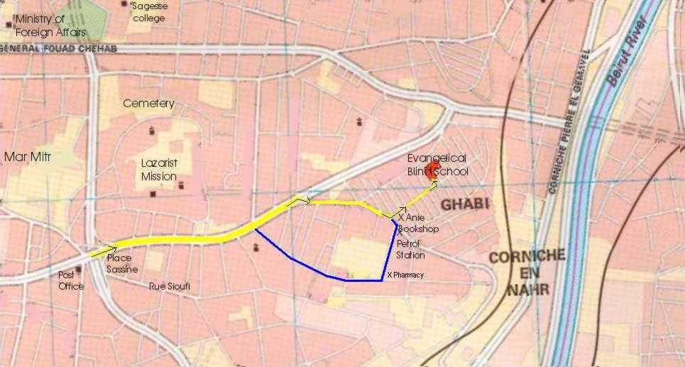
The Benevolent Lebanese Evangelical School for Special Education and Development
Ghabeh Street no. 62, Karm El-Zeitoun, Achrafieh, Beirut - Lebanon
![]()
![]()
![]()
![]()
![]()
|
|
|
| ||||||||||||||||||||||||||||||||||||||||||||||||||||||||||||||||||||||||||||||||||||||||||||||||||||
| Name of Institution | Latitude | Longitude | Lebanon EasyNav Coordinates | ||
| 1 | BLESSED (Achrafieh) | N 33° 53' 20.7" | E 35° 31' 46.6" | 33.8890 N | 35.5296 E |
| 2 | LESGB (Louweizeh) | N 33° 50' 5.3" | E 35° 34' 8.7" | 33.8348 N | 35.5690 E |
| 3 | NEST (Ras Beirut) | N 33° 53' 52.1" | E 35° 28' 56.2" | 33.8978 N | 35.4822 E |
| 4 | BESGB (Rabieh) | N 33° 55' 15.9" | E 35° 35' 51.8" | 33.9210 N | 35.5977 E |
| 5 | LES (Jdeideh) | N 33° 53' 26.7 | E 35° 33' 59.0" | 33.8907 N | 35.5663 E |
| 6 | Presbyterian Church (Rabieh) | N 33° 55' 15.9" | E 35° 35' 51.8" | 33.9210 N | 35.5977 E |
| 7 | Supreme Council of Evangelical Churches | N 33° 55' 15.9" | E 35° 35' 51.8" | 33.9210 N | 35.5977 E |
| 8 | Bible Society (Jdeideh) | N 33° 53' 20.6 | E 35° 33' 28.4" | 33.8890 N | 35.5578 E |
| 9 | YFC (Dikwaneh) | N 33° 52' 32.4" | E 35° 32' 54.8" | 33.8756 N | 35.5485 E |
| 10 | YFC (Mazraet Yachouh) | N 33° 55' 37.3" | E 35° 37' 40.3" | 33.9270 N | 35.6278 E |
| 11 | Baptist School (Mseitbeh) | N 33° 53' 4.1" | E 35° 29' 42.4" | 33.8844 N | 35.4951 E |
| 12 | National Evangelical Church (Beirut) | N 33° 53' 41.7" | E 35° 30' 4.1" | 33.8949 N | 35.5011 E |
|
|
Abbreviation |
Full Name |
|
1 |
BLESSED |
Benevolent Lebanese Evangelical School for Special Education and Development |
|
2 |
LESGB |
Lebanese Evangelical School for Girls and Boys |
|
4 |
NEST |
Near East School of Theology |
|
5 |
BESGB |
Beirut Evangelical School for Girls and Boys |
|
6 |
LES |
Lebanese Evangelical Society |
|
7 |
YFC |
Youth for Christ |
|
Send mail to
blessed@terra.net.lb with
questions or comments about this web site.
|